


eparges ranziere seuzey

ochelen
User
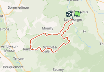

Length
27 km

Max alt
391 m

Uphill gradient
549 m
Km-Effort
34 km

Min alt
232 m

Downhill gradient
548 m
Boucle
Yes
Creation date :
2017-07-15 00:00:00.0
Updated on :
2017-07-15 00:00:00.0
10m
Difficulty : Unknown

FREE GPS app for hiking
 SityTrail
IGN / Geographical institutes
SityTrail Plus
The world is yours!
About
Trail Other activity of 27 km to be discovered at Grand Est, Meuse, Les Éparges. This trail is proposed by ochelen.
Positioning
Country:
France
Region :
Grand Est
Department/Province :
Meuse
Municipality :
Les Éparges
Location:
Unknown
Start:(Dec)
Start:(UTM)
689549 ; 5437742 (31U) N.
Comments